Johannapolder ca. 1960
Johannapolder
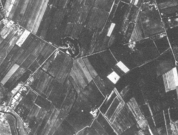
The aerial picture shows the 'Johannapolder' around 1960. The military object 'Werk aan de Hoofddijk' can easily be identified. The road 'Hoofddijk' which is of mediaeval origin runs from the fortification to the north east until it reaches the 'Bunnikseweg'. Just south of the fortification, a road streches to the south east. This is the 'Bisschopssteeg' (alley of the bishop) of which remnants can still be found north of the 'Leuvenlaan' and between the 'Bestuursgebouw' of the university and the 'Cambridgelaan'. It is preserved between the student housing 'de Bisschoppen' and Heidelberglaan 7, a building of the University of Applied Science. South of the Cambridgelaan you'll find it in front of studenten housing 'Johanna'. The 'Bisschopssteeg' dates back to the 13th century. The bishop of Utrecht seemed to have used this road to travel between the city and his home: castle Duurstede. A little further to the south buildings can be identified near the forked road. This is the farm 'De Uithof'. The curved path 'Hoge bospad' is still present as is the other road (Zandlaan) towards neighbouring village Bunnik.
The bottom left corner of the picture shows a bend in the river 'Kromme Rijn' which floats near 'De Uithof'. From there, a road can be seen, leading to the fortification. This road, known by the name 'military road' has been demolished almost entirely. Of the other road, northwest of the fortification', the 'Oostbroekselaan', a small part can still be found outside 'De Uithof', near the former Fortis office buildings of 'Rijnsweerd'.
During the 20th century, the 'Bisschopssteeg' was known as alley of 'Toon van Scherpenzeel', who was the 3rd generation farmer living at farm 'De Uithof'. In the 20s of last century young couples used to court in this alley. Apparently fear of disorderly behaviour lead to the enforcement (1924) of a local regulation stipulating that it was forbidden to sit or lie here with someone of the opposite sex.